Elevate Your Listings with Expert Real Estate Aerial Photography Techniques
Understanding Real Estate Aerial Photography
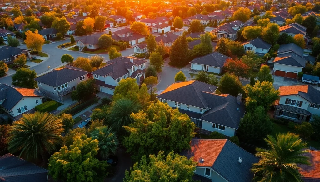
In an era where visual content dominates the real estate market, real estate aerial photography has emerged as a powerful tool that can significantly enhance property marketing efforts. This technique, which involves capturing aerial views of properties using drones or other high-altitude photography tools, provides realtors and property managers with an unparalleled angle on their real estate listings. In this guide, we will delve into various aspects of aerial photography for real estate, showcasing its benefits, essential equipment, and techniques to maximize its impact.
What is Aerial Photography?
Aerial photography is the practice of taking photographs from an elevated position, typically using drones, helicopters, or other airborne platforms. This technique allows photographers to capture a unique perspective on landscapes, buildings, and neighborhoods, revealing elements that ground-level photography simply cannot provide. For real estate, aerial photography can showcase the layout, size, and surrounding environment of properties, offering potential buyers a comprehensive view during their decision-making process.
Benefits for Real Estate Marketing
The advantages of utilizing aerial photography in real estate marketing are manifold. Firstly, it allows for the depiction of property features, such as pools, gardens, and proximity to other significant structures, which can be particularly appealing to buyers. Secondly, aerial shots can offer a broader context regarding the environment, including nearby parks, schools, and transportation links, which are crucial factors for many homebuyers. Additionally, high-quality aerial imagery can enhance online listings, increasing engagement and inquiries. Lastly, it sets properties apart in a competitive market, making listings more visually captivating and likely to be shared on social media platforms.
Essential Equipment for Aerial Shoots
To capture stunning aerial photographs, certain equipment is essential. The core tool for most modern aerial photographers is a drone equipped with a high-resolution camera. Popular models include the DJI Mavic series, known for their portability and excellent image quality. Additionally, stabilizers can help eliminate shakiness during flight, and extra batteries ensure longer shooting sessions. It’s also advisable to have editing software, such as Adobe Lightroom or Photoshop, to enhance the captures post-shoot. Other accessories, such as ND filters, can be useful for controlling light exposure during daytime shoots.
Techniques for Capturing Stunning Aerial Shots
Optimal Angles and Perspectives
Achieving the desired effect in aerial photography often hinges on the angles and perspectives chosen. The typical aerial view, a bird’s eye view from directly above, delivers a straightforward representation of the property. However, unique angles, such as 45-degree perspectives that incorporate a foreground, can create depth and interest in the photograph. Exploring different altitudes also plays a significant role; higher shots present a broad view of the entire property and its surroundings, while lower shots better highlight specific features or landscape details.
Lighting Considerations for Impactful Images
The quality of light can dramatically affect the outcome of aerial photographs. The golden hour, which occurs shortly after sunrise and before sunset, is ideal for capturing warm tones and soft shadows. During these times, the lighting enhances textures and colors, making properties more appealing. Avoiding harsh midday sunlight is essential, as it often results in overexposed images and unflattering shadows. Understanding how to work with natural light can convert standard aerial photographs into eye-catching visuals that resonate with clients.
Using Drones Effectively in Real Estate Aerial Photography
Operating drones for real estate photography requires knowledge and practice. Familiarizing yourself with your drone’s features, such as autopilot modes that assist in maintaining stable shots, can enhance your workflow. Safety is paramount; ensuring compliance with local laws and regulations, including understanding no-fly zones, is crucial to avoid legal complications. Additionally, mastering drone maneuvers allows photographers to capture dynamic shots, like flyovers or circling around properties, creating engaging narratives within their imagery.
Editing and Enhancing Your Aerial Photos
Basic Editing Techniques
Post-production editing is where the magic truly happens in aerial photography. Utilizing software like Adobe Lightroom provides tools for cropping, adjusting exposure, and fine-tuning contrast. Basic enhancements can dramatically improve the quality of photographs—adjusting brightness and saturation levels can make images more vibrant, thereby drawing in potential buyers. Furthermore, removing unwanted elements or distractions, such as power lines or cars, ensures that the focus remains solely on the property.
Color Grading and Mood Adjustment
Color grading is an advanced editing technique that helps set the mood of an aerial photograph. Warmer tones can create a welcoming atmosphere, making properties appear more inviting, while cooler tones can invoke a modern and sleek feel. Additionally, selective color enhancement allows photographers to emphasize particular features of the property, such as lush greenery or blue pool waters, creating visually striking images that can capture a buyer’s imagination.
Software Recommendations for Real Estate Photography
In the realm of real estate aerial photography, several software options stand out for their capabilities. Adobe Lightroom and Photoshop are industry standards, known for their comprehensive editing tools. For those looking for more user-friendly options, programs such as Canva for basic adjustments or Luminar for AI-driven enhancements can simplify the editing process. Evaluating personal needs and skill levels can help photographers select the right tools that align with their workflows and objectives.
Showcasing Aerial Images for Maximum Impact
Integrating Aerial Photos into Listings
Incorporating aerial photographs into real estate listings is crucial for leveraging their full potential. High-resolution images should occupy prominent positions on listing platforms, preferably as the first or second image, capturing attention immediately. Additionally, creating a virtual tour that includes aerial shots can offer potential buyers a more immersive experience. Pairing aerial imagery with detailed descriptions of neighborhood amenities can provide context that may influence buying decisions positively.
Creating Visually Engaging Marketing Materials
Beyond online listings, integrating aerial photographs into marketing materials such as brochures, flyers, and social media posts can enhance overall appeal. Infographics that combine aerial imagery with property statistics can convey information in a visually compelling way, making those materials not just informative but also aesthetically pleasing. Furthermore, professional-looking presentation videos that feature aerial footage can captivate audiences, giving a dynamic view of the property that static images may lack.
Leveraging Social Media for Promotion
Social media platforms are ideal for showcasing aerial photography due to their visual-centric nature. Instagram and Facebook offer opportunities to share captivating imagery that can quickly go viral, amplifying reach and engagement. Utilizing video stories to display drone footage in real-time can give audiences a bird’s eye view of the property and its surroundings. Hashtags relevant to real estate and local area tags can further enhance visibility and attract potential buyers.
Assessing the Effectiveness of Aerial Photography
Metrics for Measuring Success
Evaluating the impact of aerial photography on marketing efforts is essential for continuous improvement. Metrics such as engagement rates on listings, anecdotal feedback from potential buyers, and direct inquiries can provide valuable insights into effectiveness. Tracking the number of views and shares an aerial image receives on social media can also quantify its appeal. Additionally, monitoring the conversion rates before and after integrating aerial photography can help determine if the investment yielded a positive return.
Case Studies: Successful Real Estate Campaigns
Examining successful real estate campaigns that utilized aerial photography can offer practical insights and inspiration. For instance, a case study involving a luxury real estate agency showed that listings featuring aerial photography led to a 30% increase in engagement compared to those without. Another project highlighted how aerial imagery significantly reduced time on the market, as buyers were better informed about the property’s features and location. Such examples underscore the effectiveness of aerial photography in enhancing marketing strategies and closing sales.
Adjusting Strategies Based on Performance Data
Using data to inform future strategy adjustments is vital for real estate professionals. Regularly analyzing performance metrics allows photographers and realtors to identify which types of aerial shots resonate most with their audience. This insight can guide future shoots in terms of angle selection, timing, and post-production techniques, thereby continuously refining the quality of images presented to potential clients. Staying adaptable and open to changes based on performance can significantly enhance marketing outcomes and overall business success.